


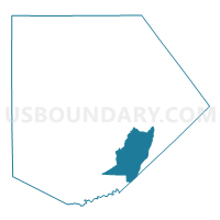
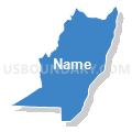
Voting District 02-2, Kendall County, Texas
About
Outline

Summary
| Unique Area Identifier | 675245 |
| Name | Voting District 02-2 |
| County | Kendall County |
| State | Texas |
| Area (square miles) | 29.67 |
| Land Area (square miles) | 29.67 |
| Water Area (square miles) | 0.00 |
| % of Land Area | 100.00 |
| % of Water Area | 0.00 |
| Latitude of the Internal Point | 29.83077440 |
| Longtitude of the Internal Point | -98.61103720 |
Maps


Graphs
Select a template below for downloading or customizing gragh for Voting District 02-2, Kendall County, Texas


Neighbors
Neighoring Voting District (by Name) Neighboring Voting District on the Map
- Voting District 0204, Comal County, TX
- Voting District 03-3, Kendall County, TX
- Voting District 08-2, Kendall County, TX
Top 10 Neighboring County Subdivision (by Population) Neighboring County Subdivision on the Map
- Canyon Lake CCD, Comal County, TX (44,736)
- Boerne CCD, Kendall County, TX (27,018)
- Comfort CCD, Kendall County, TX (6,392)
Top 10 Neighboring Place (by Population) Neighboring Place on the Map
Top 10 Neighboring Unified School District (by Population) Neighboring Unified School District on the Map
- Comal Independent School District, TX (99,194)
- Boerne Independent School District, TX (34,875)
- Blanco Independent School District, TX (6,615)
Top 10 Neighboring State Legislative District Lower Chamber (by Population) Neighboring State Legislative District Lower Chamber on the Map
Top 10 Neighboring State Legislative District Upper Chamber (by Population) Neighboring State Legislative District Upper Chamber on the Map
Top 10 Neighboring 111th Congressional District (by Population) Neighboring 111th Congressional District on the Map
Top 10 Neighboring Census Tract (by Population) Neighboring Census Tract on the Map
- Census Tract 9701, Kendall County, TX (6,392)
- Census Tract 9704.02, Kendall County, TX (6,332)
- Census Tract 9704.01, Kendall County, TX (6,101)
- Census Tract 3107.04, Comal County, TX (5,690)